Monte Baldo Excursions
Cable car rides that offer panoramic vistas and excursions on Monte Baldo are especially wonderful in the summer.
This extraordinary location offers a wide variety of alternatives to those who love the outdoors and leisure with its numerous trails of varying degrees of difficulty.
More strenuous trails can be found along Monte Baldo's ridges for the more adventurous, while those seeking a more tranquil experience can enjoy leisurely walks through meadows or the woods along paths that overlook the lake and offer breathtaking views.
Monte Baldo is also the ideal destination for Nordic Walking enthusiasts, a sport practised mainly in northern Europe that originated as a summer preparation for cross-country skiing. It can be done at any age and is an excellent way to tone the muscles throughout your body so you can balance your desire to stay in shape with your wish to take in the breathtaking views of Monte Baldo and Lake Garda.
We suggest a variety of hikes on Monte Baldo that are appropriate for families and more experienced hikers alike, and that will let you stroll along some of our mountain's most picturesque routes in safety.
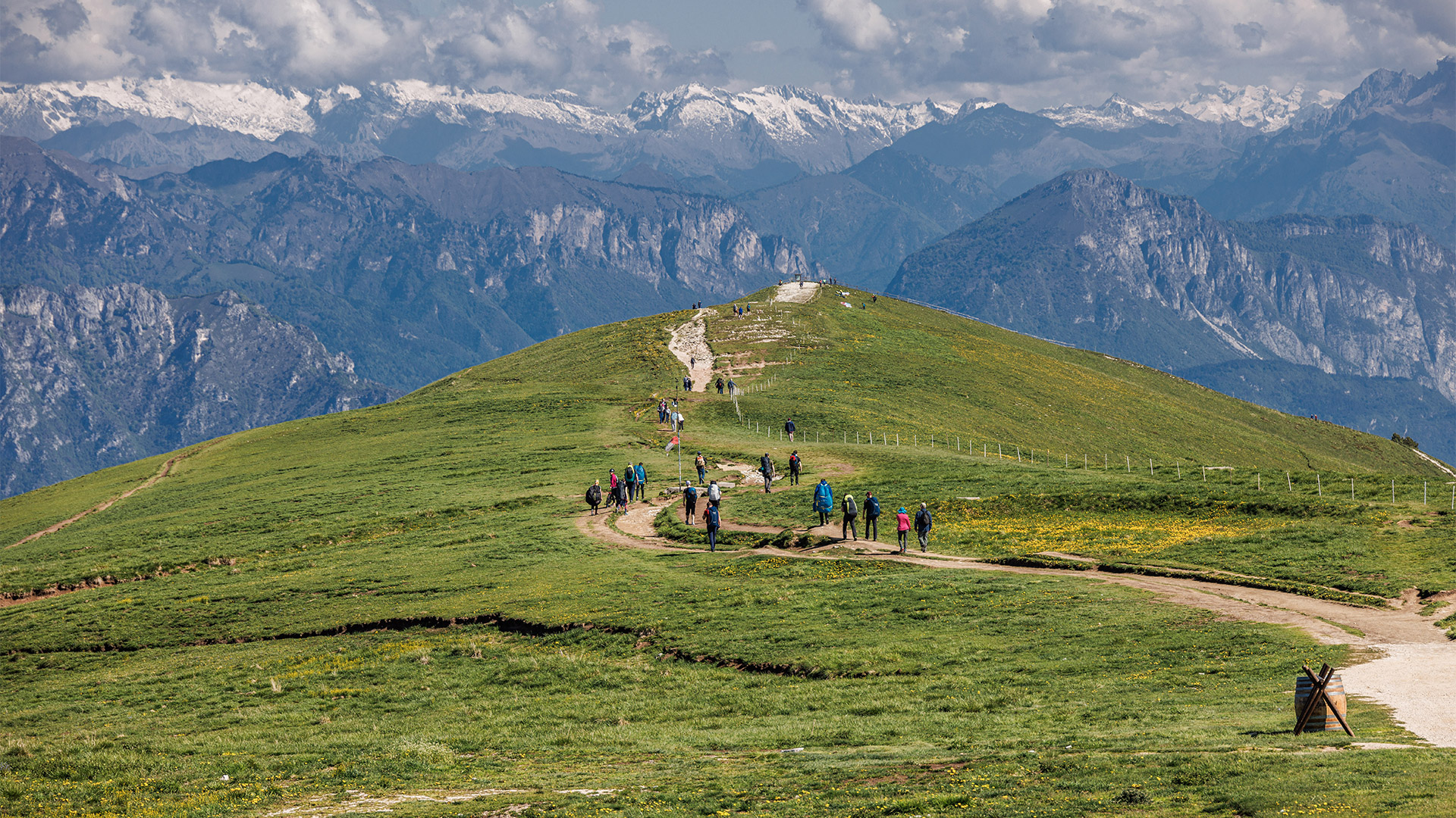
This is one of the easiest hikes on Monte Baldo that is suitable for everyone: a super panoramic walk starting from the uphill cable car station at 1760 metres asl.
After exiting the cable car, bear left and proceed another left at the wooden ski rental lodge. After a brief ascent, you will arrive at the first Lake Garda viewpoint. From here, the view sweeps over most of the lake towards the south.
Keep along the same path and, after passing the Paperino ski school lift poles, stay to the right and walk along the crest of Monte Baldo, enjoying sweeping panoramas of the Lessini Mountains, Brenta Dolomites, and Lagorai.
At the end, near the wooden fence with a bench and signs, you can enjoy the sublime view towards the northern part of Lake Garda.
At this point, the hike on Monte Baldo continues, descending to the right on a steep path until it reaches a dirt road. Turn right and return to the cable car station, heading slightly uphill, passing first by Malga Zocchi di Sopra and then the former Tratto Spino barracks.
2 hours
Time
260 metres
Height difference
3.6 km
Length
easy
Level
From the uphill Funivia Malcesine - Monte Baldo station at about 1760 metres asl, turn left on trail 651 and walk along the Malcesine Peak, a flat stretch on the Monte Baldo ridge that offers priceless views looking over the entirety of Lake Garda.
At the end, you will find a wooden fence with a bench and signs. Turn right and start to descend steeply until you reach a dirt road. Turn left, and shortly afterwards, again on the left, you will see signs for “Sentiero del Ventrar”.
Now, you plunge into the forest and walk along a narrow path dominated by high rock faces with some exposed sections secured with a metal rope (not suitable for those suffering from vertigo). During this hike on Monte Baldo, you can enjoy the views towards the northern part of the lake. They are truly unique!
Here, you leave the most challenging part behind and reach the other side of the mountain, which opens up to Lake Garda in all its beauty.
Now follow trail 16 to the left with signs for the cable car.
You walk slightly uphill through this super panoramic setting, admiring Lake Garda to the south.
Continuing to follow the signs, you reach the cable car area near the ski lift poles for the Paperino ski slope. Turn right here and return to the cable car station.
The Ventrar Trail/Sentiero del Ventrar is a short, very scenic itinerary with exposed sections and, therefore, is not suitable for those suffering from vertigo. As a result, it is classified as EE by the CAI.
2 hours
Time
500 metres
Height difference
5 km
Length
challenging
Level
From the uphill station of the Funivia Malcesine Monte Baldo at 1761 metres, turn right and follow the signs for Cima Pozzette sentiero 651 (Pozzette Peak trail 651).
Descend past the Baita dei Forti inn and walk briefly along the almost level path until you reach the start of the ascent.
Follow the path up the ridge between stones and small rocks with increasingly impressive views of Lake Garda. You will reach the arrival point of the Seggiovia Prà Alpesina and continue past a series of stone cairns that provide an impressive view of most of the lake.
Towards the middle of the trail, you will pass near the Lastoni Selva Pezzi Natural Park and continue, admiring the Baldo peaks, including Pozzette peak/Cima Pozzette, which is clearly visible.
The trail is well-marked, and the red and white colours make it easy to understand the trail's course. You will reach the steepest section near the end of this excursion on Monte Baldo, and, after 1 hour and 30 minutes, you will reach Cima Pozzette, at 2125 metres asl.
A large portion of Lake Garda, from Riva to Sirmione, is visible from the summit cross, but you can also see the Brenta Dolomites, Lessini, Colli Euganei, and the lowlands.
Return via the same path.
3 hours
Time
400 metres
Height difference
7 km
Length
intermediate
Level
This hike forms a loop and leads to the discovery of some of Monte Baldo's many malga (Alpine huts).
Head left at the cable car exit (1760 metres asl) and immediately follow dirt trail 651, which descends towards the former Tratto Spino barracks on the right.
The Guardia di Finanza (Italian Financial Police) used the building up until 1915 to guard the border between Italy and Austria, which was only a short distance away at the time.
The location of the barracks at “Bocca dei Forti” was strategic since smugglers often frequented the area.
Continuing slightly downhill on the same path, you will pass by Malga Zocchi di Sopra, which is situation at 1650 metres asl and offers a breathtaking view of the Lessini Mountains.
Here, you may sample cheese and other delicious foods made at the malga and get up close and personal with the animals.
When you reach the bend, leave the dirt road and continue along trail 651m, which heads into the woods and arrives near the paved road at Bocca di Navene,
An impressive panorama of Lake Garda greets you here.
From Bocca di Navene, follow the signs to the right for “Trekking on Monte Baldo delle Malghe e Fiori” and walk through the woods, passing by Malga Zocchi di Sotto and, further on, Malga Tratto Spino di Sotto at 1440 metres asl. After leaving the Malga, proceed to the adjacent paved road and follow the signs for the cable car on trail 14.
This segment is a part of the Prà Alpesina Nature Trail, which has many informational signs along the way so you can learn about Monte Baldo's flora, wildlife, and traditions.
Heading uphill, still within the forest, continue until you reach the former Tratto Spino barracks, then go left on the dirt road to return to the cable car station.
3 hours
Time
450 metres
Height difference
7.5 km
Length
intermediate
Level
A challenging, lengthy hike with several elevation changes, brief stretches with equipment, and breathtaking vistas. This itinerary is recommended for experienced hikers in good physical condition.
This hike to the peaks of Monte Baldo begins at the uphill station of the Funivia Malcesine - Monte Baldo, located at about 1760 metres asl. From here, we head directly south, following trail 651.
Descend slightly past Baita de Forti and start to ascend on a track that runs for about three kilometres until you reach the enchanting Cima Pozzette, at 2125 metres asl.
Along this stretch, you will enjoy breathtaking views of the waters of Lake Garda and the towering mountain ranges of the Brenta Dolomites, Lagorai, and Lessini. On a clear day, you can even get a glimpse of the Apennines and Colli Euganei off at a distance. Once you pass Cima Pozzette, the hike continues to Cima del Longino.
At this point, the landscape changes, and you move onto the eastern slope of Monte Baldo until you reach the Cima Valdritta area. Here there is a short equipped section that should be travelled with care.
Once you have reached the food of the peak, you can branch off of trail 651 and follow the path to the right that, after about a 15-minute hike, takes you to the highest peak of Monte Baldo, at 2218 metres asl.
Return on trail 651, pass the Forcella Valdritta and continue for another hour's walk to Cima Telegrafo, at 2200 metres asl. Just below it, you will find the Rifugio Telegrafo “Gaetano Barana”.
Return along the same route.
4 hours each way
Time
800 metres in ascent and 400 in descent
Height difference
9 km each way
Length
challenging
Level
The Prà Alpesina Nature Trail is one of the Monte Baldo excursions where you can learn about the local flora, fauna, and traditions. You can discover many interesting facts about this mountain, commonly referred to as the “Garden of Europe” thanks to the many signs along the path.
The Trail starts from the Seggiovia Prà Alpesina car park near Chalet Falco. From here, it takes just a few minutes to reach the uphill station at 1800 metres asl.
From the station, we take the Nature Trail to the right and walk along the ridge on trail 651 towards Funivia Malcesine Monte Baldo. Along this section, you can enjoy a magnificent panorama of Lake Garda. Behind you is the southern part, towards Sirmione, while in front, you can see the Brenta Dolomites and the Alps.
Head downhill slightly on a bed of stones and small rocks to arrive at the Bocca Tratto Spino plain. Now turn right, still following the signs for the Sentiero Naturalistico Funivia Malcesine Seggiovia Prà Alpesina. You will pass through a pasture area and descend into the woods along an easy path that becomes steeper towards the end.
The trail ends at Malga Tratto Spino di Sotto, where you cross the road, reach the malga, and then turn right, following a path the runs parallel to the road.
In just a few minutes, you will reach Malga Prà Alpesina, and from you can continue to the chairlift car park.
1 hour and 15 minutes
Time
422 metres downhill
Height change
3.6 km
Length
easy
Level